
- Status Orange wind warning for Donegal, Galway Leitrim, Mayo and Sligo in place until 11.59pm
- Status Yellow wind warning for Wexford, Cavan, Monaghan, Roscommon, Clare, Cork, Kerry, Limerick and Waterford in place until 8pm
- 32,000 without power across the country
- Extreme Weather Protocol activated by Dublin Region Homeless Executive
- A number of flights cancelled at Dublin and Shannon airports
- Racing at Punchestown cancelled
Latest: Met Éireann says the worst of Storm Brendan has passed over most of the country, but orange and yellow wind warnings remain in place.
A status orange warning for Donegal, Galway Leitrim, Mayo and Sligo is in place until 11.59pm tonight.
Head of Forecasting Evelyn Cusack says the north-west may even experience some red level winds this evening.
"For most of the country winds have dipped back into yellow [warning level winds speeds] or slightly below," said Ms Cusack
"But for the north-west, for the next number of hours, winds still into the orange levels and even gusts into the red just on the coast.
"So we're talking about say between 4pm and maybe 7pm."
A status yellow wind warning is in place for nine counties until 8pm.
The yellow warning is in place for Wexford, Cavan, Monaghan, Roscommon, Clare, Cork, Kerry, Limerick and Waterford.
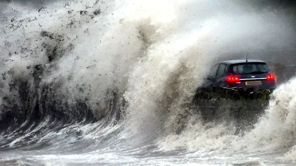
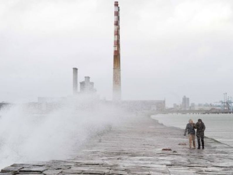
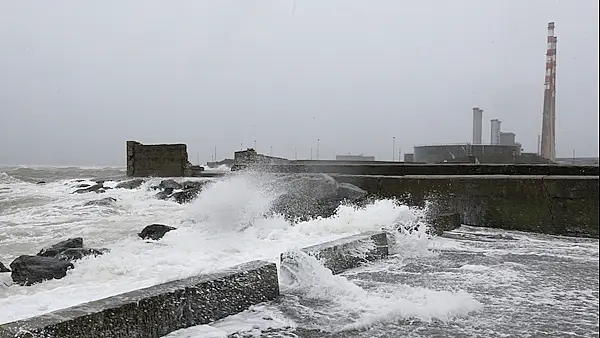
Storm Brendan hits Strangford Lough in Co Down with waves carrying sea debris causing chaos as it crashed onto traffic using the coastal Portaferry Road. Picture: Alan Lewis
The strongest gust measured during the storm so far was 135km/h at Roches Point weather station on the south coast.
Meanwhile, ESB crews are working to restore power to 32,000 homes and businesses around the country, but the said the majority should see it restored this evening.
They said that Wexford, Waterford and Kerry are now the worst impacted areas.
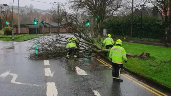
The ESB said in a statement that the damage "is mainly attributable to fallen trees on overhead lines as a result of the high winds".
The statement added: "Crews will continue to carry out repairs into the evening, where and when it is safe to do so.
"With Met Éireann Orange level winds now once again being experienced in the Northwest, further outages may occur.
"Crews have made good progress restoring power along the Western seaboard this evening and we expect the majority of those 32,000 families and businesses without power to have their supply restored by tonight.
"Crews will deploy once again from before first light tomorrow to reconnect those without power overnight."
At its worst, 48,000 homes and business were without electricity earlier in the day.
Those without power are being urged not to take matters into their own hands.
The ESB's Derek Hynes urged people "not to take any action themselves to try and restore power or to try and remove debris from [the] network."
In Galway, homes and businesses are bracing themselves for high tide this evening just after 7pm.
Flood defences remain in place, with sandbags being provided by Galway City Council over fears the tail end of Storm Brendan could bring flooding to the city.
In Dublin, the city council said that in advance of high tide today, car parks were closed and flood defences were erected at Clontarf, Sandymount, and along the tidal reaches of the River Dodder.
They said that the flood defences will remain in place until Wednesday morning.
Update 3.20pm: Storm Brendan: New orange and yellow warnings issued; Almost 50,000 without power
Met Éireann has updated its orange wind warning and also issued a new yellow wind warning.
Storm Brendan rolls into Dublin. Picture: RollingNews.ie
Storm Brendan has been sweeping across the country with 48,000 premises nationwide currently without electricity.
Winds of up to 130km/h have also pulled down dozens of trees across the country.
The orange wind warning is now in place for Donegal, Galway Leitrim, Mayo and Sligo.
The forecaster has said: "As Storm Brendan tracks away from Ireland, southwesterly winds will continue to reach mean speeds of 65 to 80km/h with gusts of 100 to 130km/h, higher in exposed areas.
"There is a significant risk of coastal flooding due to the combination of high spring tides and storm surge."
The warning came into effect at 2.30pm and will be in place until 11.59pm tonight.
A status yellow wind warning is now in place for nine counties.
The warning for Wexford, Cavan, Monaghan, Roscommon, Clare, Cork, Kerry, Limerick and Waterford came into effect at 3pm and is in place until 8pm this evening.
Storm Brendan in Galway. Picture: PA Wire
Met Éireann says that "southwest to west winds will reach mean speeds of 50 to 65km/h with gusts of 90 to 110km/h, highest in exposed areas."
Meanwhile, it is expected that the number of homes and businesses without power could rise further.
Derek Hynes from the ESB is anticipating further outages in the North West this evening.
"We're starting to deploy our staff in the west of Ireland as the weather has passed over," he said.
"What we expect is for the rest of the evening is another band of really heavy winds to come in at around four o'clock.
"We expect them to hit the Galway, Mayo, Sligo, Donegal part of our network. So we are expecting further outages in the north west."
Update 2pm: Storm Brendan: Almost 50,000 without power as storm makes its way across country
ESB spokesperson Derek Hynes has updated the number of homes and businesses without power to 48,000 with most of them in Kerry, Galway and Mayo.
The number is likely to rise as Storm Brendan crosses the country he told RTÉ radio's Today with Séan O'Rourke show.

Pedestrian pictured in Cork city centre during Storm Brendan. Picture: Daragh Mc Sweeney/Provision
An orange wind warning is in effect nationwide with gusts of up to 130km/h expected.
The storm is forecast to be at its strongest up until 2pm this afternoon.
A fire crew attends to a fallen tree in the city. Picture: Cork City Fire Brigade
"Further strong winds will impact the rest of the country, but we will get power back to as many as possible," he said.
Crews are already out conducting repairs where possible he said, while managers carry out risk assessments.
Remote repairs are also being conducted in control rooms.
"We will deploy repair crews where necessary when we can."
The counties most impacted include Galway, Limerick, Kerry, Cork and Donegal.
ESB Networks crews have been dispatched in the most affected areas when safe to do so, assessing the damage so that they can restore power as quickly and effectively as possible.
Real time information on power outages and restoration times is available on the PowerCheck App or esbpowercheck.ie.
The body responsible for looking after Dublin's homeless has activated its Extreme Weather Protocol.
The Dublin Region Homeless Executive is asking people to let it know about any rough sleepers they see.
Teams are on standby to encourage people out of the storm, and into emergency shelter.
Inner City Helping Homeless has advised that their office at 67 Amiens Street is open until 10pm.
People can come to the office for a change of clothes and a cup of tea.
The Capuchin Day Centre on Arran Quay will be open and serving hot meals until 3pm.
A section of the main street in Ballincollig County Cork has been closed after a section of roof peeled off a building as Storm Brendan raged.
Traffic diversions are in place as emergency services monitor the situation at the western end of the town.
The alarm was raised just after 10.30am when a section of roof fell from the building which houses the Tradehouse Central bar.
Luckily there was nobody on the path outside at the time and there were no injuries.
Members of Cork City Fire Brigade are on the scene and they are escorting shoppers to their cars parked in an adjoining carpark close to the damaged to building.
A number of engineers are also on site but are waiting for an improvement in weather conditions before conducting an inspection of the roof.
The Castle West shopping centre is open and trading as normal.
Local Fianna Fáil Cllr Colm Kelleher, who visited the scene earlier, praised the emergency services for their swift responses and said he was glad that no-one was injured.
Met Éireann's Head of Forecasting Evelyn Cusack is urging the public to keep up to date on local conditions.
"So it is going to improve from the west through the morning and early afternoon but then there is going to be another traunch of heavy winds and heavy squally showers into the north-west later in the afternoon and evening."
Winds up to 120km/h have already been reported in the south-west as winds began to peak.
Heavy rain is pushing into many areas at the moment although it remains reasonably dry in the east.
Ms Cusack said that there will be “several hours of very dangerous weather”.
“Thankfully the storm centre is keeping out to the north-west of Ireland but we are going to get several hours of dangerous weather as that transfers across the country,” she said.
Ms Cusack said that pressure is falling rapidly in the west where winds are picking up and there is a risk of localised flooding, local structural damage and uprooted trees.
It is estimated that as the storm pushes eastwards, each area will get at least two-three hours of peak intensity winds.
Storm Brendan is expected to clear the east coast by roughly 2pm.
The threat of flooding in the west and south has subsided for the moment but in the east high tide will be at 1pm.
This will coincide with the peak of the storm along the east coast bringing with it a high risk of coastal flooding early in the afternoon.
This risk will rapidly decrease from about 3pm.
An animal charity is urging pet owners to ensure their animals are safely indoors.
The Irish Society for the Prevention of Cruelty to Animals (ISPCA) warned that with strong winds and heavy rain forecasted, animals can get easily distressed.
The ISPCA strongly recommended that you keep your pets securely indoors.
Carmel Murray, Society spokesperson said: “Cats in particular are great at finding warm spots to sleep, but sometimes these can be dangerous.
They often take shelter under the bonnet of a car, so make sure to bring them in and always check for sleeping cats before you drive off.
“Check inside sheds and other outdoor structures as they may have taken shelter there and become locked inside and also check doors and gates after the storm for any damages.
"Larger animal including horses and farm animals should be brought inside in a secure stable or shed, so that they are shielded from heavy rain and flooding, and kept safely away from falling trees and flying debris.
"It is important your pets are microchipped as a permanent form of identification should they escape."
If your pet should escape, the Society said pet owners should contact their local pound, animal rescue centres and local vet, in the event they have picked it up.
21,000 without power as storm brings 'violent winds'

Picture courtesy of https://earth.nullschool.net/
Update 11am: The whole country is now under a status orange wind warning with "violent" winds expected.
Met Éireann is warning of damaging gusts of up to 130 km/h as well as a significant flood risk.
The storm, which originated off the coast of Canada, will hit the west of the country – from Kerry to Donegal – between 10am and 11am and will then move across the country to hit the east coast at lunch time.
Since 5am this morning, all of Connacht, Donegal and Kerry have been on alert, and that is valid until 9pm tonight.
A second alert came into place for the rest of the country at 8am which is valid until 3pm this afternoon.
The head of forecasting at Met Éireann Evelyn Cusack has warned the public to observe warnings about Storm Brendan.
“All areas will get storm force winds,” she told RTÉ radio’s Morning Ireland.
This will mean ground saturation, localised flooding, there will also be the danger of uprooted trees and the possibility of structural damage, warned Ms Cusack.
This is an Orange warning for all counties and a Red warning for marine counties, she added.
Along with heavy rain, there will also be thunder storms.
According to the ESB, there are 21,000 homes and businesses without power due to the storm.
Around 4,000 people are without electricity in Kerry this morning as the storm named after the county's native saint hits.
Most of the outages so far are in Cahersiveen and south Kerry along with west Kerry.
There are outages along the west coast of the country with Kerry and Cork the worst affected at the moment along with areas in Galway, Mayo and Sligo.
Trees have come down in north Kerry and the public are being asked to avoid altogether the Killarney National Park.
The early morning Kerry to Dublin flight has been cancelled and a number of scheduled events in Tralee have also been postponed.
While Storm Brendan will pass over the country in a matter of hours, the north-west will experience “a second blast” this afternoon said Ms Cusack.
The combination of spring high tides, storm surges because of low pressure, storm force winds and thunder storms means Storm Brendan will be very powerful.
“We are going to be getting several hours of very dangerous weather,” she warned.
Galway City Council’s Gary McMahon told the same programme that this morning’s high tide had passed but that the full force of the storm had not hit yet.
Sections of the sea front at Salthill promenande were closed and an enforced boom at Spanish Arch was “very effective”.
Car parks at Salthill had been cleared, although two cars remained, so far flooding had not occurred.
Mr McMahon advised the public to exercise extreme caution in shore areas and to adapt the Coastguard advice to “stay high, stay back, stay safe.”
The temporary boom at Spanish Arch will remain in place for this evening’s high tide, he added.
The local authority is working with the OPW for a more permanent solution, but the temporary solution seemed to be working well.
Mr McMahon advised the public to keep up to date through social media.
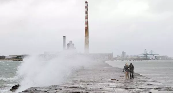
Steps are being taken by Dublin Port today due to high tides and Storm Brendan.
It will temporary close public access to the Great South Wall from 11am this morning and North Bull Wall Bridge from midday.
Meanwhile, Dublin City Council has put up flood defences and closed the car parks at Clontarf and Sandymount due to the storm.
Dublin City Council Senior Engineer, Colin Fitzpatrick says they will be keeping an eye on the River Liffey too.
"The main areas where we will be working on are Clontarf and Sandymount, we will also be monitoring all other areas along the both sides of the Liffey - both north and south - from Heuston Station down to Dublin Port.
"We don't envisage any problems along that area but we will be monitoring them throughout the day."
Fingal County Council says sandbags are available for collection from its Watery Lane Depot in Swords.
High tide is expected at 1pm with the threat of coastal flooding in places like Sutton, Malahide and Balbriggan.
Rescue crews are warning the public to stay away from exposed coasts saying today is not a day to take chances.
Louth County Council has closed all parks and playgrounds until further notice.
Council staff put flood defences in place and sandbags have been distributed to key locations, the council confirmed.
It has sandbags available for collection in Blackrock, Carlingford, Dundalk and Drogheda.
It has also advised residents and motorists in Ship Street, the North Quay and Wellington Quay in Drogheda and on the Inner relief road/Quay street, the Newry Road, the Racecourse road, the Blackrock road (Connolly's Corner), Blackrock Main Street, Annagassan and Baltray to be aware of the potential for flooding and not to park in those areas.
They are also advising people to be prepared and have their phone charged, have a working torch, a supply of candles and batteries and to secure bins and outdoor equipment.
Gerard O'Flynn, Head of Irish Coast Guard Operations, says breaking waves along the coast can be unpredictable.
"Standard message from the Coast Guard is to stand back, stay high, stay dry," said Mr O'Flynn.
"We would also ask that people who may be experienced in the water not to be engaging in recreational activities because that will draw the attention of concerned members of the public."
The national director of the National Directorate for Fire and Emergency Management has urged cyclists not to be on the roads today during the Orange weather warning for Storm Brendan.
Sean Hogan told RTÉ radio’s Morning Ireland that cycling will be very dangerous today with “very intense rain” and high winds.
Conditions will be very difficult and dangerous, especially on the roads, he warned.
Mr Hogan said that fallen power lines and trees will be expected along with “a certain level of damages”.
Local authorities have been preparing and will respond to any incidents as the storm crosses the country.
It is important for the public to check with their area’s local authority to remain up to date on issues such as fallen trees, power lines, localised flooding and structural damage.
Mr Hogan pointed out that the early morning high tides had passed without difficulty, but he warned that conditions are very difficulty and he urged the public to be careful especially on the roads.
The National Parks and Wildlife Service (NPWS) has advised people not to visit National Parks, National Monuments or Nature Reserves while the weather warnings are in place.
The following locations are closed:
- Killarney House and Gardens, Co Kerry
- Muckross House and Gardens, CoKerry
- Dromore Woods Nature Reserve, Co Clare
- Coole Park & Gardens Nature Reserve, Gort, Co Galway
- Connemara National Park, Co Galway
- Knockma Woods Reserve, Tuam, Co Galway
- Wild Nephin/Ballycroy National Park (closed since October and will remain so until late March)Additional reporting by Vivienne Clarke
First weather warning in place as storm hits west coast
Update 6.40am: The first of two status orange wind warnings is in place as Storm Brendan tracks to the north west of the country.
All of Connacht, Donegal and Kerry have been on alert since 5am and that warning is valid until 9pm tonight.
From 8am this morning, a second alert will come into place for the rest of the country which is valid until 3pm.
Met Éireann is warning of a significant flood risk and damaging gusts of up to 130 km/h.
The National Directorate for Fire and Emergency Management (NDFEM) says all coastal areas could experience coastal flooding.
Keith Leonard, head of the NDFEM, has warned people to stay away from exposed coastal areas for the duration of the storm.
"We would appeal to motorists to slow down and be aware of the very hazardous situations that could arise with debris and fallen trees and to be very aware of vulnerable road users as well," said Mr Leonard.
The Irish Coast Guard is warning that breaking waves along the coast can be unpredictable and quickly drag you away.
"The centre of the storm is passing off the north-west coast of Ireland and is going to generate very strong winds - southerly winds in particular - up to storm force conditions which is quite severe," said Gerard O'Flynn, Head of Irish Coast Guard Operations.
"On top of that, tides are at their peak and there will be very high tides so the combination of southerly winds and very high tides is going to lead to difficultlies along a lot of coastal areas."
Local authorities have activated their local co-ordination and crisis management arrangements.
Dublin City Council is putting up flood defences in the capital and has closed the car parks at Clontarf and Sandymount.
Dublin City Council Senior Engineer, Colin Fitzpatrick says they are also taking steps along the River Dodder on the southside.
"We will be monitoring today the levels in the River Dodder and it is highly likely that some of the flood gates along the river in the Ballsbridge area, around the AIB-Aviva Stadium area may be closed for a period of time."
Dublin Port Company will temporarily close public access to the Great South Wall (from 11am to 4pm) and the North Bull Wall Bridge (12 noon to 2.30pm).
Any power outages can be reported to ESB Networks on 1850-372-999, with the public being reminded to never approach or touch fallen electricity wires.