The South East is set to get a freezing cold blast of winter – just as we head into spring.
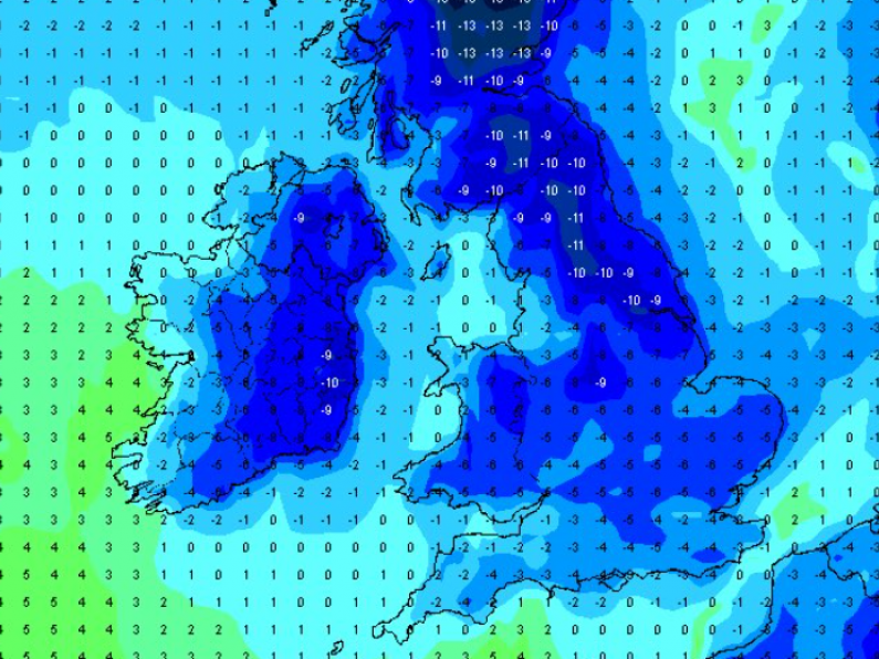
An Arctic airmass is set to move down over Ireland from early next week, driving temperatures down and bringing the possibility of wintery falls.
Temperatures will begin to decrease as we go into Sunday, with a further dip on Monday. Tuesday will be bitterly cold with a strong wind chill driving temperatures down even further.
Dry, cold air will limit the possibility of widespread precipitation but showery falls of sleet and snow remain a possibility.
Tweeting earlier today, Carlow Weather's Alan O'Reilly noted that the latest charts "rolling out from GFS model show a real blast of cold air very likely next week now."
Latest charts rolling out from GFS model showing a real blast of cold air very likely next week now. Windchill will feel bitter next Tuesday and Wednesday and a risk of some wintry showers but largely dry for most on current outlook. pic.twitter.com/aMSHXjGMxR
— Carlow Weather (@CarlowWeather) March 2, 2023
The outlook beyond Thursday is less certain. A warmer southwestern airmass could try to push up over Ireland, which according to Alan O'Reilly's Carlow Weather could be "a battle of airmasses" that will either result in snowfall or rain.
Commenting on the forecast cold spell, Met Éireann said: "Monday night will be very cold with temperatures dropping well below freezing as colder air moves over the country from the north. From Tuesday on it is expected to be colder with the chance of any showers turning to sleet and snow, although currently, all indications suggest it will stay largely dry."
Latest animation of upper air temperature forecast shows that cold air plunging down from the North next week. A chance of wintry showers early next week but a lot of uncertainty beyond Thursday with a battle of air-masses that could see a snowy breakdown or quickly turn to rain. pic.twitter.com/6Lf3PsB1UN
— Carlow Weather (@CarlowWeather) March 2, 2023


